MLA Vilnius Productive Landscapes
Studying foodscapes within the course Productive Landscapes
This page is still in development and will be completed during the course which is offered to Master Students of the Landscape Architecture Programme of Vilnius Tech- Vilniaus Gedimino technikos universiteto
Topic of the course
Productive landscape concerns the current problems of foodscapes, food systems, short chains, food security.
This module addresses the planning, design, and management of sustainable foodscapes, integrating both environmental, social, and economic aspects of the productive landscape. It addresses the main challenges, theoretical frameworks, approaches, and methods for sustainable food planning. It relates to the concepts of food security, food safety, food democracy, and food justice and the way stakeholders and communities can address the challenges by participatory action research and living labs.
It builds upon the work of the International Panel of Experts in Food Planning (IPES) and the Resource Centre on Urban Agriculture and Food Security (RUAF). It includes mapping a food system, mapping the stakeholders, consumers, policy makers (power mapping), and carrying out a SWOT analysis. Students work on collaborative goal setting (applying the nominal group technique for systematic working); proposing transformative actions, developing scenarios, alternatives, and implementation strategies. It may relate to the relevant studio project.
Aim of the course
After completing the foodscapes part of this module, students should be able to conceive ideas in a collaborative way for the future physical interventions of a part of a local-regional food system in relation to its context. The goal is to develop adequate knowledge and understanding of food systems, to define driving forces, understand the planning process, to decide on transformative actions, and to make planning and design proposals.
Learning outcomes
The student/learner:
- Understands the concept of food systems in their cultural, local and regional setting.
- Is aware of contemporary challenges to sustainable food systems in context of spatial planning.
- Develops an understanding of the multiple dimensions of food systems: social, environmental, economic and spatial.
- Can map and evaluate a concrete situation of a food system, making use of a transparent method, to define the most relevant challenges.
- Can formulate an approach and/or a possible solution for a selected challenge that is related to his/her own competences and role in the system.
- Can define her/his own position and values regarding sustainable food planning
- Is able to reflect on his/her own process, using feedback from others reflecting on cultural, social and economic differences.
Lectures, Q&A. and presentations
Preparatory activities
You are asked to view the introduction by Carolyn Steel Hungry Cities by Carolyn Steel video
And to read the IPES report A Long Food Movement.
IPES-Food, 2021. A long food movement. Addresses global challenges and opportunities for transforming food systems towards sustainability. This comprehensive report emphasizes the urgent need to overhaul current food systems to address pressing issues such as climate change, biodiversity loss, inequality, and public health concerns. It outlines a vision for a sustainable food future, where long-term planning and grassroots movements play key roles.
Deh-Tor, C.M. . 2017 From Agriculture in the City to an Agroecological Urbanism: The transformative pathway of urban (political) agroecology, in: Urban Agriculture Magazine no. 33 – Urban Agroecology. From this publication the focus is on the introduction, page 5 until page 13.
If you have time to do so, it would be nice also to read the Summary of From Plate to Planet.
- IPES-food: From Plate to Planet: How local governments are driving action on climate change through food.
Reading material before October 7, 2024
Countryside Charity (CPRE – UK) - just read the 7 pages that explain the toolkit.
You can also have a look to the complete website: https://www.cpre.org.uk/resources/mapping-local-food-webs-toolkit-2/
FAO. 2019. FAO framework for the Urban Food Agenda. Rome. https://doi.org/10.4060/ca3151en Helps to understand the policy context and frameworks that guide urban food systems, aligning with understanding sustainable food planning concepts.
Food and agriculture organisation. FAO Report : "Integrating food into urban planning“ page 18 - 32.
FAO. (2018) City Region Food System Toolkit, Assessing and planning sustainable city region food systems, publication of FAO, RUAF and Wilfrid Laurier University. http://www.fao.org/in-action/food-for-cities-programme/toolkit/introduction/en/ (introduction page 1-3, schemes page 133-144 (p. 138-149 in pdf).
Short Introduction, on-line, September 9, 2024
Introduction, overview course, concepts, first excercise.
1 Current challenges of the food system, global trends and regional perspective
Online, September 16, 16h20 – 17h50 Estonian Time
You can view the presentation here.
2 City region food mapping methods and cases on multi-scale levels
On-site, October 7, 16h20 – 17h50 EET
3 Food governance, food councils, multilevel governance.
On-site, October 7, 18h10 – 19h40 Estonian Time
4 Agro-ecological urbanism: concepts and building blocks
Online, October 14, 15h20 – 16h50 EET
5 Agriculture in a global context
Online, October 14, 17h10 – 18h40 EET
6 Urban agriculture and the commons
Online, October 28, 15h20 – 16h50 EET
7 Food security, food justice and food democracy
Online, October 28, 17h10 – 18h40 EET
Student's presentation and discussion
Online on November 4 and November 18, 15h20-16h50 EET
Q&A session on the assignement
Online November 25, 15h20-16h50 EET
Exercises
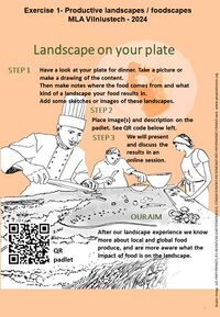
Exercise 1, landscape on your plate
The first exercise is meant to create a greater awareness of the relation between the food that we eat and the landscape that it results into.
STEP 1: Have a look at your plate for dinner. Take a picture or make a drawing of the content. Then make notes where the food comes from and what kind of a landscape your food results in. Add some sketches or images of these landscapes.
STEP 2: Place image(s) and description on a padlet. You will receive a QR code.
STEP 3: We will present and discuss the results in an online session.
Assignment
The content of the assignement will be defined during the first weeks of the course.
You can find a draft of the assignment here.
